
What is Google My Maps?
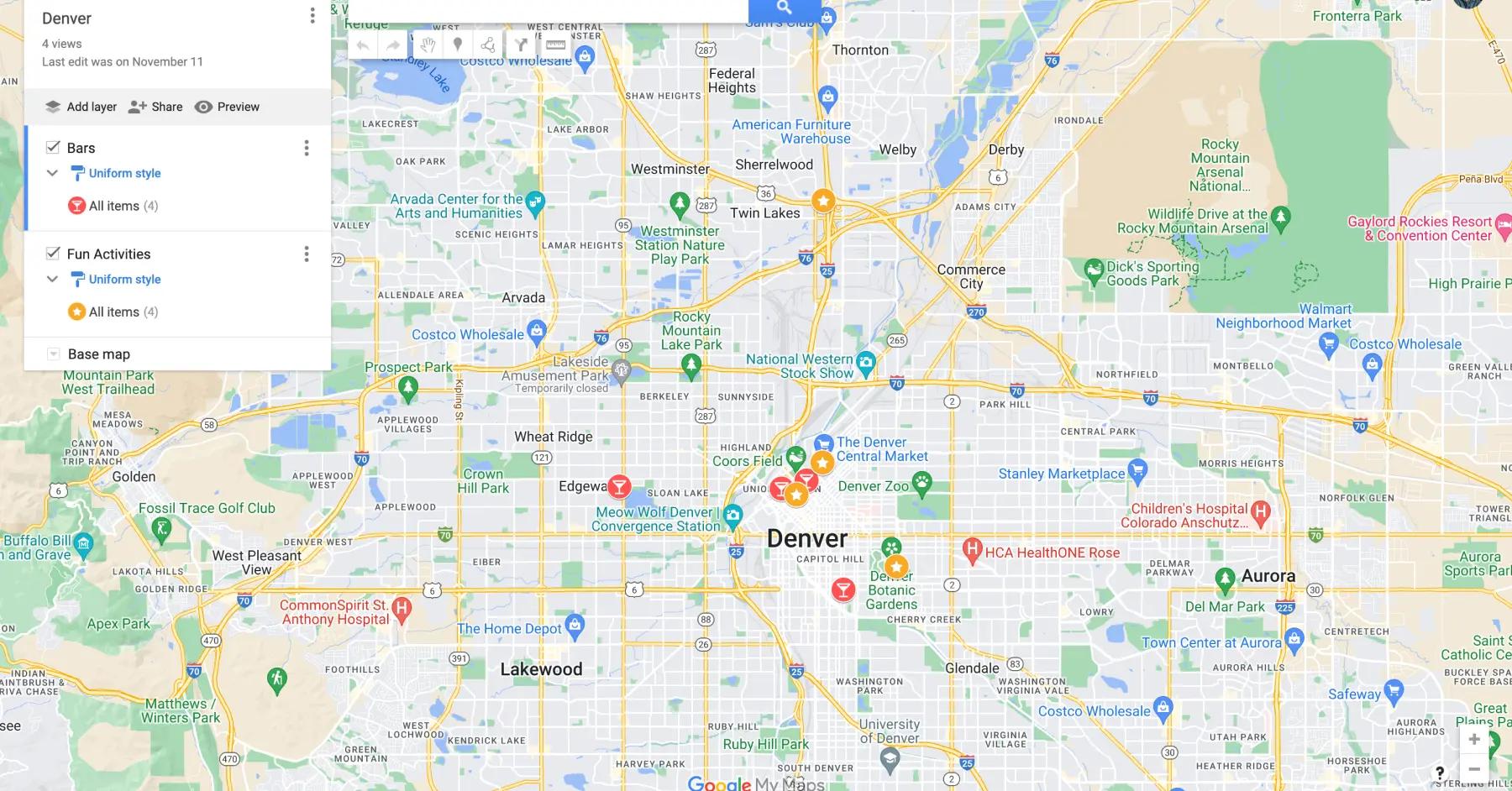
Google My Maps is a free tool for creating custom maps. Users can add locations, draw shapes, embed images, and personalize maps for travel, projects, or sharing with others.
Details
- Pricing
- Free to use
- Mobile app
- Not available
- Best for
- Creating custom maps, ideal for visualizing and marking locations for trips.
- Website
- Visit Google My Maps
Pros & Cons Of Using Google My Maps
Pros 😊
- Custom Map Creation: Offers unparalleled flexibility for creating personalized maps with layers, markers, and notes.
- Integration with Google Ecosystem: Syncs well with Google Drive and other Google services.
- Free to Use: No cost for accessing its features, making it an economical choice.
Cons 😭
- Steeper Learning Curve: The interface can feel overwhelming for first-time users.
- No Offline Functionality: Requires internet access to view or update maps.
- Lack of Group Collaboration: Limited real-time collaboration compared to other tools.
Exploring The Top Features Of Google My Maps
Layer-based trip organization
Google My Maps enables travelers to create up to 10 distinct layers per map, each containing up to 2,000 locations. This powerful system allows you to separate hotels, restaurants, activities, and daily itineraries into organized, color-coded layers that can be toggled on and off for clarity during planning.
This organizational approach transforms complex multi-destination trips into manageable visual segments, making it easy to focus on specific aspects of your journey without overwhelming clutter.
Real-time collaborative editing
The platform mirrors Google Docs functionality, allowing multiple travelers to simultaneously plan trips together. Changes appear instantly across all users, making group travel planning seamless. You can share maps with view-only or full editing permissions, and integrate with Google Groups for team access.
This collaborative feature eliminates the back-and-forth emails and conflicting spreadsheets that often plague group travel planning.
Advanced data import capabilities
Google My Maps accepts CSV files, Excel spreadsheets, Google Sheets, and KML/KMZ files up to 2,000 rows each. This feature transforms existing travel research into visual maps instantly, whether importing restaurant lists from spreadsheets or GPX tracks from previous adventures.
The import process includes options to color-code and style markers based on data categories, making it easy to convert research into actionable travel maps.
Rich media integration
Each location marker can embed photos, videos, detailed notes, website links, and contact information. Maps can store comprehensive trip documentation, from restaurant hours and reservation notes to photo galleries and YouTube videos showcasing destinations.
This multimedia approach creates living travel guides that serve as both planning tools and lasting trip memories.
Custom styling and visualization
The platform offers extensive personalization through custom icons, colors, and marker styles. You can upload your own icons, choose from hundreds of built-in options, and create color-coded systems that make complex itineraries instantly understandable at a glance.
Advanced users can create highly sophisticated visual hierarchies that communicate travel priorities and logistics effectively.
Comprehensive export functionality
Maps support KML/KMZ formats for universal compatibility with other mapping applications and GPS devices. Maps can be embedded in websites, exported for offline reference, or shared through direct links with customizable permissions.
This flexibility ensures your travel planning work can be used across different platforms and shared with various audiences.
Multi-modal route planning
The system integrates driving, walking, cycling, and public transit directions directly into custom maps. While not as sophisticated as dedicated route planners, it provides essential navigation between locations with turn-by-turn directions accessible through the Google Maps mobile app.
Routes automatically update when you modify destination sequences, helping optimize travel logistics.
Distance measurement tools
Built-in rulers calculate point-to-point distances, multi-point path measurements, and polygon area calculations. These features prove invaluable for understanding spatial relationships between destinations and estimating travel times.
The measurement tools help identify realistic daily itineraries and prevent over-ambitious scheduling.
Google ecosystem integration
Maps automatically save to Google Drive without using storage quota, connect with Google Photos for image embedding, and sync across all devices where you're signed into your Google account. This seamless integration eliminates file management concerns.
The ecosystem integration ensures your travel planning work is always backed up and accessible across devices.
Unlimited map creation
There are no account restrictions on map quantity, meaning you can create separate maps for different trips, maintain ongoing collections of favorite places, or build comprehensive regional guides without storage or quantity limitations.
This freedom allows for detailed organization strategies that suit individual travel planning styles.
Built-in location search and discovery
The platform leverages Google's comprehensive location database, making it easy to find and add destinations through powerful search functionality. You can discover nearby attractions, restaurants, and services while building your itinerary.
The search integration provides access to business hours, contact information, and user reviews directly within the mapping interface.
5 Reasons You'll Love Using Google My Maps 😍
1. Exceptional visual trip planning
Transform abstract itineraries into clear geographical understanding that reveals logical routing opportunities and helps identify unrealistic schedules—preventing common travel planning mistakes.
2. Zero cost with premium features
Get sophisticated mapping capabilities, unlimited maps, collaborative editing, and data import/export functionality completely free, while competitors charge $35-60 annually.
3. Superior desktop planning experience
Enjoy unmatched detail and precision for pre-trip research with full-screen interface, comprehensive toolsets, and ability to import research data from spreadsheets.
4. Effortless collaboration without barriers
Enable seamless group planning where participants don't need premium accounts or app downloads—sharing works through familiar Google Drive permissions.
5. Permanent trip documentation
Preserve travel memories and research indefinitely through Google Drive integration, creating living documents that provide lasting value beyond initial trip planning.
5 Reasons You Might Not Love Using Google My Maps 😭
1. Complete absence of mobile editing
You can only create and edit maps on desktop browsers, forcing travelers to return to computers for any trip modifications—severely hampering spontaneous adjustments during travel.
2. No offline functionality
The platform requires constant internet connection for viewing custom content, creating problems in remote locations or when managing data costs abroad.
3. Missing automated travel features
No flight tracking, reservation management, automatic itinerary creation, or intelligent recommendations—everything requires entirely manual data entry and research.
4. Restrictive technical limitations
Only 10 layers per map, 10,000 total items maximum, and 2,000 features per layer force awkward workarounds for complex trips or comprehensive regional guides.
5. Lacks specialized travel tools
No budget tracking, expense management, route optimization, or travel-specific integrations compared to dedicated platforms like Wanderlog or TripIt.
Summary
Google My Maps occupies a unique position as the premier free visual trip planning tool in a market dominated by subscription-based mobile-first applications. While it excels at detailed pre-trip visualization and group collaboration, it fundamentally serves as a mapping platform rather than a comprehensive travel solution.
The platform's greatest strengths lie in its sophisticated customization options, unlimited collaborative features, and zero cost barrier that makes it accessible to all travelers. Its visual approach to trip planning reveals geographical relationships that traditional itinerary lists cannot convey, making it particularly valuable for complex multi-destination trips and group travel coordination.
However, Google My Maps faces significant limitations that prevent it from serving as a complete travel solution. The complete absence of mobile editing capabilities, lack of offline functionality, and missing automated features like flight tracking or reservation management create substantial gaps in the modern travel planning workflow. These limitations force users to supplement with additional tools during actual travel.
Still, for travelers who prioritize detailed pre-trip planning, group collaboration, and visual organization—especially those working with limited budgets—Google My Maps offers an unmatched combination of features and functionality. Most successful users employ it as their primary planning tool while supplementing with specialized mobile apps during travel, creating a hybrid approach that leverages each platform's strengths.
Frequently Asked Questions (FAQ)
Can I edit Google My Maps on my phone?
Unfortunately, no. Google My Maps only supports full editing through desktop web browsers like Chrome, Firefox, or Safari. Mobile devices can view maps through the Google Maps app or mobile browsers, but you cannot create new maps, add markers, or modify existing content on phones or tablets. For any meaningful editing during travel, you'll need access to a laptop or desktop computer.
Does Google My Maps work offline?
Google My Maps has no official offline functionality, which represents one of its biggest limitations for travelers. Unlike regular Google Maps that allows downloading map areas for offline use, custom My Maps require an internet connection to display properly. For reliable offline mapping during travel, dedicated apps like Wanderlog Pro, Roadtrippers, or downloaded areas in standard Google Maps provide better solutions.
How many locations can I add to a single map?
Each Google My Maps can contain up to 10,000 total items across all layers combined, with a maximum of 10 layers per map and 2,000 features per individual layer. For most travel planning, these limits prove generous, but comprehensive regional guides or detailed road trip routes can hit these boundaries. When you reach limits, you'll need to create additional maps or remove less important content.
Can I import my existing travel spreadsheets into Google My Maps?
Yes, Google My Maps supports importing data from CSV files, Excel spreadsheets, Google Sheets, and KML/KMZ files. Each import can contain up to 2,000 rows of data, and the platform automatically recognizes location information from address columns or coordinates. You can import restaurant lists, hotel information, or any location-based spreadsheet data, transforming existing research into visual maps instantly.
How does Google My Maps compare to paid travel planning apps?
Google My Maps excels as a free visual planning tool but lacks the automated features of premium travel apps. Compared to TripIt, it cannot track flights or parse email reservations but offers superior map customization. Against Wanderlog, it misses AI recommendations and mobile editing but provides better collaboration features. Versus Roadtrippers, it lacks specialized road trip tools but offers more flexible route visualization. Many travelers successfully combine My Maps for planning with specialized apps for on-the-road functionality.
Alternatives

Wandrly
Create limitless travel lists, share with friends and family, and prioritize the places you want to visit the most.
Learn more
Roadtrippers
A road trip planner that plans your trip for you.
Learn more
Google Maps
Navigation, directions, location search, and real-time traffic updates worldwide.
Learn more
Polarsteps
Travel tracking app that automatically creates travel logs and maps to document trips.
Learn more
Wanderlog
Plan and organize travel itineraries, collaborate, and manage bookings efficiently.
Learn more
Tripomatic
Travel planner that offers interactive maps, activity suggestions, and itinerary management.
Learn more